By Hamza Shuaib
Live event production is becoming challenging because of evolving audience expectations, market saturation, and operational complexities. Festivals are growing in acreage, touring schedules are tighter, and the margin for error in site logistics is virtually non-existent.
For production managers and safety directors, the challenge is no longer just putting on a show; it is managing a temporary city with military-level logistical complexity. As events grow, ground-level planning tools do not always offer situational awareness.
CAD maps are outdated and ground-level spot checks hardly capture the entire flow of a site. This gap in intelligence is where aerial imaging in live event production has shifted from a marketing luxury to a practical necessity.
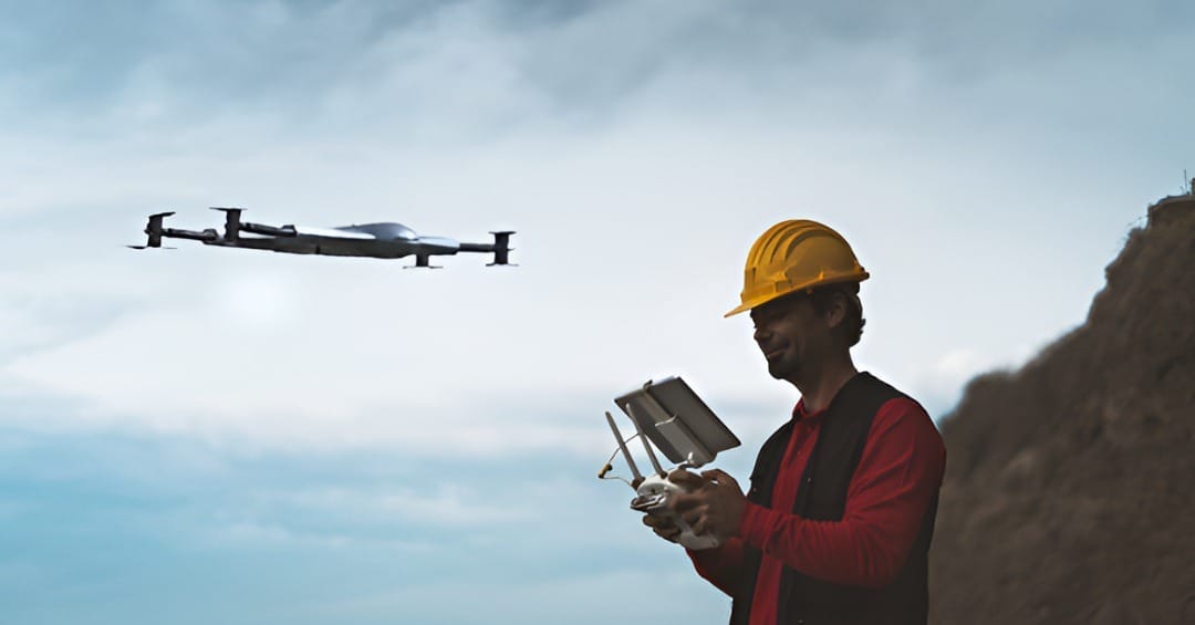
Industry adoption is moving away from using drones solely for "after-movie" B-roll. Instead, aerial data is being incorporated into production crews to confirm the plans of the site, monitor safety measures, and enhance the load-in/load-out process.
As a means of operational assets, aerial imaging is the best solution to offer the top-down visibility necessary to reduce risk and ensure schedules in the increasingly complex industry.
How Event Teams Use Aerial Imaging in Practice
Event teams use aerial imaging to enhance situational awareness, improve safety, and elevate storytelling across events. By capturing high-resolution, real-time footage from drones or other airborne platforms, teams gain a bird’s-eye view that reveals spatial dynamics, crowd movements, and venue layouts invisible from ground level.
1. Logistics and Venue Planning: Site Validation
Before the first truck arrives to load in, production teams are using aerial imaging to create precise, georeferenced digital twins of the venue to preemptively solve layout conflicts.
In greenfield sites or temporary festival grounds, satellite imagery from Google Earth is often months or years old. It does not involve recent construction, erosion, or vegetation changes.
By deploying drones for photogrammetry (connecting hundreds of images into a high-resolution 2D map (orthomosaic)), teams can superimpose the current site conditions onto their CAD drawings. This creates a validation layer for event operations planning, allowing technical directors to:
- Check that ground conditions can support heavy staging and cranes.
- Identify obstructions in load-in paths that do not appear on older maps.
- Accurately mark perimeter fencing and the emergency escape routes based on the existing topography.
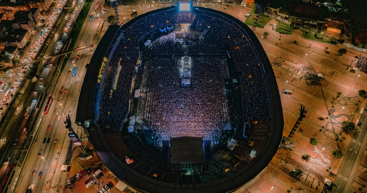
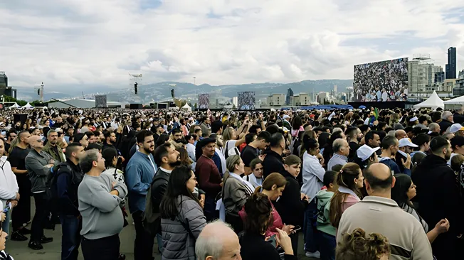
2. Crowd Monitoring and Safety Oversight
As soon as the doors open and the venue is filled with people, the operational focus changes to crowd safety monitoring, and situational awareness turns into crowd safety monitoring.
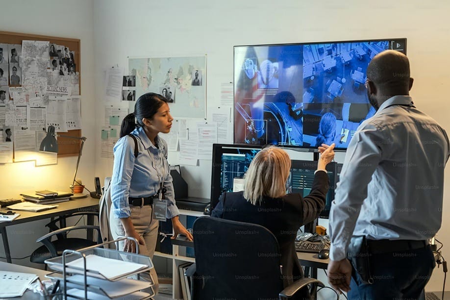
In the past, safety officers relied on fixed CCTV positions and ground spotters, both of which have blind spots. Aerial imaging acts as a mobile sensor, capable of repositioning instantly to areas of concern.
Operationally, this enables the safety command center to identify pinch points where the crowd density is hazardous before it explodes. Attendance flow can be analyzed by viewing the attendants moving upwards. Hence, the organizers can take informed decisions on whether to open the overflow gates or to divert the traffic.
This real-time aerial oversight gives a full picture of the crowd dynamics that cannot be viewed by the ground teams.
3. Production Coordination
During critical build days, a festival site becomes chaotic with hundreds of vendors and heavy machinery. This requires production coordination that ground-level checks cannot capture. This is where aerial views take place in auditing back-of-house operations.
Production managers monitor semi-truck queues to prevent loading dock traffic jams and ensure vendor compounds are within designated areas. They also ensure that cable routes are secure and correctly routed. This aerial perspective serves as a daily check, making sure that the build aligns with the construction schedule.
4. Post-Event Analysis and Compliance
The operational utility of aerial data for events extends well beyond the final curtain call, serving as a critical tool for liability protection and future site optimization. Post-event high-resolution imagery of the site gives a conclusive remediation and compliance record.
In the case of festivals in the parks or in the private areas, aerial photographs record the state of the ground following the load-out, which support damage claims or environmental rehabilitation.
Moreover, the analysis of the time-stamped footage of ingress and egress patterns enable operation teams to consider the bottlenecks and prepare the sites better in the following year's edition.
Real World Use Cases
While specific registered site data is rarely publicized by major promoters, the strategic application of these aerial workflows is becoming standard practice across three primary sectors of the industry.
The Greenfield Festival Model
For multi-stage music festivals held in remote locations, crowd flow management is the primary challenge. Organizers are increasingly using tethered drones (drones connected to a power source for unlimited flight time) to monitor the transition periods between headliners.
When 50,000 people move from the Main Stage to Stage B, the aerial view informs the control room exactly where to deploy barricades or redirect flow to prevent congestion.
Touring Production Logistics
In large-scale stadium tours, the advance team must assess the viability of a venue’s loading dock and backstage area. Aerial imaging allows the tour manager to visualize the turning radius for trucks and the placement of the production village in unfamiliar venues. This pre-visualization reduces the "figure it out on the day" stress that often plagues tight touring schedules.
Corporate and Large-Scale Activations
For corporate clients, accuracy is vital in the business world. Production leads use aerial views to confirm that activations are oriented for the best possible exposure, rather than guessing from the ground. This ensures the client sees the exact layout they approved in the pitch deck.
Challenges and Considerations
While drones offer value, incorporating them into live event production brings challenges. Here are some common hurdles producers face and how they are being addressed:
- Regulatory Requirements: The most critical challenge is the regulation regarding flying drones over crowds. Direct flights of heavy drones directly over a crowd are rigorously controlled and forbidden in the US (FAA Part 107) and Europe (EASA) without certain waivers and safety precautions (parachutes).
- Safety and Risk Management: A drone is a mechanical object with rotating blades. Bringing one into a live event environment introduces liability. Operators must have strict flight paths that avoid suspending the aircraft directly over the audience, preferring to fly over "sterile" areas like security lanes or back-of-house zones.
- Technical Limitations: Live events are hostile environments for wireless signals. The massive amount of RF (Radio Frequency) noise from wireless microphones, radios, and production comms can interfere with drone control links. Professional operators must use hardware capable of navigating high-interference environments.
- Weather and Battery Life: Unlike fixed cameras, drones are limited by wind speed, rain, and battery endurance. They are a tool for specific missions, not a 24/7 "eye in the sky" solution unless tethered systems are utilized.
Because of these challenges and the regulatory complexity, many teams rely on licensed drone services to handle compliance, flight operations, and risk management.
What’s Next for Aerial Imaging in Live Events
As drone technology advances, the industry is shifting from simply "seeing" to actively "analyzing" data, thanks to AI integration in event production logistics.
We're moving toward AI-assisted planning, where software can automatically count attendees in specific areas from aerial footage. With the use of computer vision, production teams will soon use aerial feeds to extract real-time density statistics which enable predictive planning.
Additionally, there is a narrowing between the drone operations and the event management. Aerial data streams will be included in current event systems in the future. Rather than showing drone feeds on a dedicated screen, it will be integrated directly into central command screens, such as CAD-based digital twins. This will give a geospatial view of the whole production team.
Conclusion
Aerial imaging is rapidly shifting from a “nice-to-have” feature to an essential tool of event infrastructure that helps in safety and logistic support. Faster visualization of the overall operational environment in real-time is a necessity in the world where efficiency and security are constantly questioned.
For modern productions, the aerial camera view is not just a beautiful sight, it offers authority and control. By utilizing aerial imaging in the live events production, organizers bridge the gap between plans and reality so that when the lights go down, the show runs smoothly.
Hamza Shuaib is an industry analyst focused on live event production and the operational use of drone technology. He writes about how drones and aerial imaging enhance safety, logistics, and efficiency in large-scale events.